This article aims to present the hikes in an area close to the house and delimited as indicated by the following map:

Hiking trails are available in the neighboring towns of Grand-Fort-Philippe: Gravelines and Oye-Plage to the west, Saint-Georges-sur-l'Aa and Bourbourg to the south, and Craywick and Loon-Plage to the east. Discover this region of the "Rives de l'Aa" (banks of the Aa), and you'll undoubtedly be quickly charmed by the quality of our environment and the welcoming locals.
The map below displays walking trails between Grand Fort Philippe and Gravelines. The list is accessible from the arrow icon to the left of the map title.
Vaubanauxislandais circuit.pdfDownload PDF • 823KB
GRAVELINES-Gravelinescircuit-de-la-Forte.Download • 2.05MB
fortress_maritime.pdfDownload PDF • 1.58MB
Circuit_cyclo_vauban_nature.pdfDownload PDF • 537KB
CARTE_CYCLO.pdfDownload PDF • 4.93MB
The completed files and descriptions below come from the V sitesisorando , Northern Trail, from the blog Walking storyDetailed access is available by clicking on the trail title. In addition to a detailed itinerary, you will find the stories and legends that mark each of the circuits and the points of interest.
The Ansérienne trail LANSERIENNE TRAIL.pdfDownload PDF • 2.27MB
This path allows you to cross the maritime plain which stretches as far as the eye can see, and to discover, within the dune massif, a preserved natural space: The Platier d'Oye National Nature Reserve.
The Platier d'Oye PLATIER TRAIL.pdfDownload PDF • 1.34MB
The trails are marked. They are accessible in both winter and summer, and the hike I'm offering allows you to discover our beautiful northern beaches. The White Lady of the Bell Towers, along the Oye River
THE WHITE LADY TRAIL.pdfDownload PDF • 2.41MB
Just a few kilometers from the coast, this walking trail, which runs partly along the River Oye, is ideal for families. It's an invitation to discover a countryside still dominated by mills and traditional farmhouses, witnesses to the intensity of agricultural life in these lands crisscrossed by numerous waterways called "wartergangs."
Chicory mills and drying houses around the Oye River MILLS AND DRYERS CYCLO CIRCUIT.pdfDownload PDF • 2.14MB
Long ago, the sea covered this territory during high tides, but the ingenuity of Benedictine monks in the 10th century made it possible to build a network of drainage canals: the watergangs. This territory, with its light, sandy soil, favors the cultivation of chicory. Large buildings made of yellow or red bricks were once used to dry chicory root. People took advantage of this gift from Mother Nature by building mills.

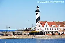
This stage finally brings us back near the coast to Gravelines. After Bierne, a long walk begins along the Haute Colme Canal, lined with traditional houses. It then reaches Bourbourg and then changes direction to reach Gravelines via the village of Saint-Georges-sur-l'Aa.

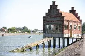
The route returns to the coast at the beautiful Aa estuary and Fort-Grand-Philippe. It then crosses the Platier d'Oye nature reserve. It continues along a large beach, returns inland, and arrives at the Jules Ferry Centre. It then reaches the Calais Centre.
Around Hennuin
ORIENTATION COURSE_HENNUIN_tous_post.Download • 1.42MB
This path, where land and water merge, is a walking route that allows you to follow the watergangs (drainage work intended to drain low marshes and wetlands) and observe animal and plant species specific to wetlands as a family.
DAUDRUICQ TRAIL.pdfDownload PDF • 3.95MB
Audruicq is a rural town center known for its Wednesday morning market, one of the largest and most typical in the region. In 2019, it was ranked the 4th Most Beautiful Market in France. Audruicq's rural vocation is celebrated every year, two weeks before Easter, during the famous agricultural competition that brings together stakeholders from the farming world.
Marsh Trail in Nortkerque MARSH TRAIL.pdfDownload PDF • 1.80MB
This trail takes you to one of the four villages of the Pays du Brédenarde, Nortkerque, which translates as "Northern Church." Geologically, the former Pays du Brédenarde is composed of a layer of clay lying on the chalk overlooking the maritime plain. It is a land of bocage, hedges, fruit trees, and livestock. Formerly, the Brédenarde also included the communes of Audruicq, Zutkerque, and Polincove.
From the Guines forest to Lake Ardres along the canals Discover the Calais countryside by visiting the towns of Guines and Ardres, or even exploring cycle paths and other country roads by mountain bike or hybrid bike along the edge of forests, lakes and fields.
The Wolf Lady Trail LADY OF THE WOLF TRAIL.pdfDownload PDF • 2.66MB
South of Audruicq, discover the Brédenarde, a land of hedgerows, hedges, and fruit trees. From Zutkerque or Polincove, take the Dame aux Loups trail, a tribute to Baroness de Draëck. You can admire her castle, the first hills of Artois, and follow the winding path of the Hem: the river of mills.