The main historical events of Fort Philippe, from the Pays des Morins to the Opal Coast

The origins of Gravelines: At the time of Julius Caesar's conquests, the Pays des Morins, of which Gravelines was a part, was invaded by the waters and the peoples who inhabited the few emerged parts, such as Bergues, Watten, Saint-Omer, came from the rest of Germania. The North Sea began to withdraw from the land between the year 1000 and the 12th century, favoring the establishment of houses barely set back from the coastal strip. The Aa winds capriciously from the hills of Artois and branches into a delta while waiting for men to tame it around the 12th century. These men were not Gravelinois but inhabitants of Saint-Omer, of which Gravelines was for a long time the outer port. The waters receded and many hamlets were formed: one of them, whose name is unknown to us at that time, located on the current site of Les Huttes, was later to become Gravelines. The origins of the territory on which Gravelines was established therefore remain closely linked to the various stages of the formation of the northern coastline and the Flemish maritime plain. The birth of this hamlet cannot be dated precisely. In fact, the history of Gravelines really begins only in 800, following the construction of a chapel in honor of the Evangelist Saint Willibrord, an Anglo-Saxon bishop. The work of reclaiming the land by dikes, plodderization, and canalization is developing. A small town and fishing hamlet, Gravelines was founded in the 12th century in the County of Flanders by Thierry and Philippe (his son) of Alsace, to serve as an outport for Saint-Omer. Like most towns in Flanders, for a long time it was content with a thick earth embankment surrounded by a vast water ditch with only gates and towers built of solid material, given the scarcity of stone.
The town, created between 1159 and 1163, first received the name of Nieuwpoort, which should be translated as New Town, then that of Graveningis, one of the old names of this region, a name which would gradually transform into Gravelines. The establishment of a fishing village first, then of a town fortified by the Count of Flanders, were conditioned by the presence of the sea and the delta of the Aa, one of the smallest coastal rivers in France and which has its source in Bourthes (62) and thus delimits the border between the Pas de Calais and the North. The town prospered quickly: the outer port of St-Omer, salt, fruits and wines from the southwest were unloaded there every day and fishing, especially herring, was actively practiced there. The new town acquired statutes and franchise and developed a certain prosperity linked to maritime trade and fishing. However, it was not without its ups and downs. Located on the natural border of the Aa, Gravelines became a site of wars, devastation, and pillaging. In turn, the Dukes of Burgundy and the Kings of Spain called Gravelines home. In 1212, Philip Augustus, King of France, ravaged the town to punish the Count of Flanders for not allying with him against the English. In 1302, under Philip the Fair, Oudard de Maubuisson took the town and sacked it again, as did the English in 1383 after the capture of Calais. In the 15th century, Gravelines was in the power of the Dukes of Burgundy, Counts of Flanders. Nothing remains of the late medieval wall (14th and 15th centuries) except for the location of the two gates, Calais and Dunkirk. In 1558, it resisted the assault of Marshal de Thermes, French governor of Calais. Gravelinga, Land of Spain: The war between Francis I and Charles V led the latter to rebuild the four bastions of the square and to reinforce the Castle because the city had insufficient defenses. The ovoid enclosure had to be made of a thick palisade earthwork overlooking the ditch with gates and a few towers built of brick. The city began to take shape and the hexagon was ready to await the enemy who could appear from all sides. Charles V made the city a strategic stronghold. Between 1528 and 1535, a brick castle dominated the access to the east of the city and the lock of the Bourbourg canal. The latter was rebuilt and transformed into a flush lock, capable of emptying the mud from the estuary at each equinox tide. His son, Philip II of Spain, transformed the city wall upon his arrival on the throne in 1556: a modern rampart with six large bastions and glacis integrated the medieval walls. The castle bastion was transformed and included in the hexagonal wall. The Italian engineers Olgiati, Thebaldi and Saluberto supervised the construction sites. On July 13, 1558, the Count of Egmont won a major battle against the French for the Spanish. After the capture of Calais by the Duke of Guise, a French offensive had been launched on Flanders by Marshal de Thermes. On December 22, 1565, an agreement was reached at Gravelines by the commissioners of the King of France and Spain on the new border between the two countries; Near the Oye lock, the fort built by the Spanish must be demolished (they undertake to do so) and "the buildings and roofs will be new, and the barrier will be put back in the middle of the bridge of Oye."
On July 29, 1588, the Invincible Armada was attacked by English fireships off the city, forcing the Spanish to divert to the North Sea.
Valentin de Pardieu, governor of Gravelines in 1574, opted for the Spanish side during the War of Independence and had to defend the city on several occasions against the Confederates, the French and the English.
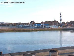
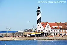
In 1608, the English Poor Clares, Catholic nuns persecuted in their country, arrived in Gravelines and settled in the street that now bears their name. They built a convent and chapel there. The Recollet Brothers did the same in 1630. The successors of Philip II of Spain continued the modernization work. In 1635/38, the Spanish dug a canal from Gravelines to the North Sea. They had the "Fort Saint-Philippe" (Fort St-Philippe) built at the mouth of the Aa at the site known as the "Flaque des Espagnols". This mouth was canalized to protect the anchorage. A horn-shaped structure and a small bastion to the east protect the locks. The natural protection of the dike against high tides to the west and the advance of the dunes allow the appearance of a few agricultural cottages. The channel advances, straight, towards the horizon marked by the two fishing villages established on the site of the two forts built under Philip II: Grand-Fort Philippe which was in fact larger than the other and which was long called Fort Saint-Philippe and Petit-Fort Philippe, today the hamlet of Gravelines. There, the sky, the earth and the wave seem to have worked together to compose the landscape.
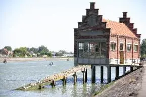
French Gravelines: Alternately French in 1644, Spanish in 1652, this town was definitively ceded to France by the Treaty of the Pyrenees in 1659 while Boulogne and Calais were recovered from the English a century earlier as indicated above. Dunkirk was definitively purchased from the English in 1662. The current channel opposite the house of Bouteille à la mer, built by the Spanish in the first half of the 18th century, was destroyed by a French attack in 1658. The borders of present-day France were gradually taking shape, we were under the reign of Louis XIV who imposed a policy of Frenchification: preaching, administrative correspondence, and trials would now be conducted in French. A measure all the more necessary for merchants as the linguistic border with France was located on the Aa. One man would take the destiny of Gravelines in hand: Vauban. He would continue and expand the defensive works outlined by the Spanish. In 1680, after Louis XIV's visit to Gravelines, Vauban was tasked with drawing up a new plan for the town. He therefore improved its defenses, notably by equipping its ramparts with ravelins, counterscarps and glacis and by installing a lock on the Aa. In the square, Vauban planned the construction of military and civil buildings (casemated cistern, bread oven, barracks, etc.) and transformed the medieval castle into an arsenal. Despite its position behind Dunkirk, Vauban, in 1699, considerably reinforced the town's defenses by adding a second belt of ravelins commanding a covered foreway.
The fortifications were modernized at the end of the 17th century, based on a report and a project by Vauban, appointed governor of Gravelines in 1706.
For his part, he only carried out the remodelling of the counterscarps and the lower town structure and especially the Vauban lock between the Aa and its estuary, protected by a hornwork (now disappeared).
Within the fortified enclosure, four military buildings are grouped together: a guardhouse, an infantry barracks called Varennes (1735 – 37), a barracks called Uxelles, a casemated cistern (1724) as well as the church
Saint-Willibrord (1598).
https://youtu.be/_wZlifAsSLIIn the square, Vauban planned the construction of military and civil buildings (casemated cistern, bread oven, barracks, etc.) and transformed the medieval castle into an arsenal. Despite its position behind Dunkirk, Vauban, in 1699, considerably reinforced the city's defenses by adding a second belt of half-moons commanding a covered foreway.
The fortifications were modernized at the end of the 17th century, based on a report and a project by Vauban, appointed governor of Gravelines in 1706.
For his part, he only carried out the remodelling of the counterscarps and the lower town structure and especially the Vauban lock between the Aa and its estuary, protected by a hornwork (now disappeared).
Within the fortified enclosure, four military buildings are grouped together: a guardhouse, an infantry barracks called Varennes (1735 – 37), a barracks called Uxelles, a casemated cistern (1724) as well as the church
Saint-Willibrord (1598).
A new channel was dug from 1738; Louis XV took up the channel project of Philip IV and completed the construction of the fort, crossed in its middle by the channel. During these years, the Spanish works were restored and the construction sites continued. The ramparts underwent a major renovation: the enclosure tripled in width thanks to the construction of half-moons, counterscarps, redans and a covered way. It was completed in 1740 and a flush lock was built to remove sand from the channel. In addition, he completely revised the hydraulic system by installing a "large flush lock", protected by the hornwork; by releasing the sluice gates downstream, the channel could now be removed from sand all the way to the sea; By closing the floodgates upstream, large areas of land around the town can be flooded; this is a "defensive flooding" device: Gravelines is a strategic town that regulates water levels and navigation on the inland canals, by keeping the water in its ditches and moats.
Among the French towns in the network of fortified places, Gravelines is the only one to present an example of this military architecture located between the medieval fortress and the modern-day citadel with geometrically profiled bastions. All of Gravelines' fortifications and the water-filled moats remain and are open to the public. The arsenal houses the Museum of Drawing and Original Printmaking; a copy of the original relief plan is visible in the basement of the Gravelines powder magazine. Only an anchorage point at the mouth of the Aa Canal, named Fort Saint-Philippe, recalls the location of the fort built by the Spanish. The relief plans are models of strongholds, executed from 1668 onwards. An instrument of military and strategic use, they represented the towns and their surrounding countryside up to the limits of artillery firing range. They made it possible to envisage possible enemy attacks and thus improve or build military works. The collection grew in line with the annexations of Louis XIV and Louis XV. After the war of 1870, the construction of the relief maps was completed. The collection now includes around a hundred maps, including that of Gravelines, built shortly before 1758 and restored in 1810 and 1819. The 1756 relief map, produced at a scale of 1:600, repaired in 1771 and 1819, is preserved at the Museum of Fine Arts in Lille.

In 1902, the Gravelines stronghold was declassified and became the property of the State, but for economic reasons, the ramparts were fortunately not destroyed. Following the commissioning of the Vauban Basin, the port movement tended to develop. It was only from 1897 that dredging could be carried out using equipment from the port of Dunkirk and, since then, trade took off; to meet its legitimate needs, the Basin was enlarged and a jetty was built at Grand-Fort-Philippe; these works were completed in 1907.
Autonomy of Grand Fort Philippe: Before 1740, there was only the farm called "LOUF" and a few agricultural cottages on the side of Fort Saint Philippe. It was the digging of the channel at the end of the 18th century that led some sailors and traders from "Huit" to settle on its west bank. Grand-Fort-Philippe was born. In 1768, there were 22 day laborer households and 3 fishermen households. In 1871, the Vauban lock was rebuilt, a floating dock was created; timber quays were built along the Aa and those of the dry dock and the small Fort Philippe were raised.
The church of Grand Fort, largely betrothed by sailors, was opened to the faithful on October 1, 1862. The autonomy of Grand-Fort-Philippe was accepted by approval of the municipal council of Gravelines and implemented on January 1, 1884. On January 27, the municipal council, which was elected on the 13th, met for the election of the first mayor of the commune; Charles Eugène Carney was designated, while Joseph Leprêtre was elected Deputy Mayor.
Throughout the 18th century, the population grew steadily, reaching 20 heads of families practicing fishing in 1785: Agez, Creton, Daubercourt, Dollet (or Daullé), Dubois, Fournier, Lamour, Lefebvre, Lemaire, Noyel, Plachaux, Potier, Wadoux.
It was at this time that the local identity of Grand-Fort-Philippe was forged from its dialect first, a dialect of Picard origin mixed with maritime terms, which allowed it to differentiate itself from the people "del ville" (from Gravelines, a Flemish town) but also from its customs and its eating practices focused on the preservation of fish.
Gravelines & Grand Fort Philippe in the 20th century:
Gravelines is first and foremost a fishing town. Cod fishing off the coast of Iceland in the North Sea has long been one of the main activities of Gravelines sailors, with the fleet numbering up to 100 boats at the beginning of the 20th century.
In 1902, the Gravelines stronghold was declassified and became state property, but for economic reasons, the ramparts were fortunately not destroyed.
This enabled the town to courageously resist the Germans for a week in May 1940 while the Allies were evacuating Dunkirk. Gravelines was awarded the Croix de Guerre in 1950. Today, the port of Gravelines is no longer a major commercial port. Pleasure boats have permanently replaced the schooners, and only a few fishing boats continue to sail. Until 1938, cod fishing was one of the main activities of Gravelines sailors, with the fleet numbering up to one hundred boats. Port trade and maritime fishing boomed until the 1960s. Every year in February, sailors boarded luggers, schooners, and later dundees to go fishing, for more than six months, off the Icelandic coast. To encourage them, the locals greeted them with a ritual upon their departure and return from these campaigns. After more than a century of existence, this ritual, which punctuated fishing "in Iceland," continues to live on every year through the famous carnival and the Icelandic Festival. In 1995, the town of Grand-Fort-Philippe created a giant named the Matelote. She immortalizes its fishermen's wives, who raised their children, repaired the nets and sold the fish, while waiting for their husbands to return. A beautiful brunette with green eyes, dressed in black and white, adorned with period jewelry, the Matelote has been the wife of the Icelander from Gravelines, a fisherman in Iceland, since 1998. Both ensure the memory of these heroic destinies. They had twins, Nette and Fiu, in 2003, and in April 2009, the third child, "Gut," was born. Think about it when you contemplate the horizon towards the sea.https://youtu.be/Mk27nATXkV4On the Grand Fort Philippe side, the fishing epic began in 1830 and continued until 1940. In 1906, there were 740 sailors for 3,500 inhabitants and only 9 of them owned their boat. All the municipalities that followed one another during the first half of the 20th century had the objectives of developing fishing production, educating young Philippois and cleaning up the streets. Despite the various misfortunes that befell this town: 1888 and 1895, dark years for fishermen, the Great War which left 138 soldiers dead for France and the crisis of the 1930s which eliminated the activity
maritime of the Icelanders. During the Second World War, the city was captured by the Germans on May 27, 1940, after a day of resistance at the place called "The Black Pig". The day before, the British War Cabinet decided: "...only one way out remains for you: to fight your way to the west, where all the beaches and ports located east of Gravelines will be used for embarkation. The navy will provide you with a fleet of ships and small boats, and the Royal Air Force will give you full support..."
From May 28 to June 4, 1940, the Battle of Dunkirk took place, Operation Dynamo, the evacuation of the British and French armies along a corridor between the Dunkirk area and the small Belgian port of Nieuwpoort. The operation was a major success of the Second World War. The words printed in the columns of the American newspaper "The New York Times" the day after Operation Dynamo remain relevant: "As long as English is spoken, the name Dunkirk will be spoken with the greatest respect."
Grand-Fort-Philippe was liberated on September 7, 1944, by Canadian troops. https://youtu.be/t9x1kKz0kfI https://youtu.be/X8n0DnK8Nuo Once an economic hub with a fishing fleet that peaked at 170 boats at the beginning of the 20th century and a renowned training center with the school for fishermen (in place of the Museum of the Sea), Grand-Fort was nicknamed Little America and was richer than Gravelines. The boom was halted by the First World War and the decline confirmed by the Second. An attempt at recovery took place with the return of peace, but irreversible decline was announced. The community then turned to other horizons, the economic reconversion turned towards industry and tourism. The information comes from:
- sites of the town of Gravelines, the Gravelines Marina, Vauban Sites, Nordmag, personal blog, wikipedia Grand Fort, webnord,
- publications such as A nous Fort-Phillip, Instant des Forts, Jean Bart, Corsair of the Sun King (Patrick Villiers), Vauban, the intelligence of the territory, Vauban (Bernard Pujo),
- references and web sources on the activities of the Corsairs' race between Dunkirk and Boulogne: site of the corsairs of Calais, Dunkirk, Boulogne, a personal blog on the history of the North, the exhibition of the Tourville association in Gravelines, site of La Défense, the H Van Der Zee Company.


